Data
Population Health
These sets of indicators are organized based on the Population Health Model. Together, they provide a comprehensive view of the people who live, learn, work and take part in activities and community life in the province.
Primary Health Survey
The Primary Health survey aims to better understand and report on New Brunswickers' self-rated health determinants, their use and their experiences with primary health services in their communities. The survey results are available at the provincial, health zone and NBHC community levels across four survey cycles: 2011, 2014, 2017 and 2020.
Student Wellness and Education Survey
This survey aims to understand and report on several aspects of students’ wellness and education.
Home Care Survey
This survey evaluates the quality of publicly funded home care in New Brunswick from the perspective of citizens who receive these services.
Publications
-
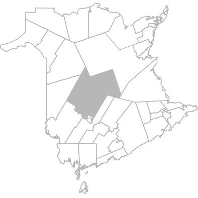
Population Health Profiles 2022 - Douglas, Saint Marys, Doaktown Area
This overview of the health and well-being of people who live, learn, work and take part in activities in our province is designed to create a shared understanding of our local unique realities.
Overview
Geography
This community is part of Zone 3 - Fredericton and River Valley Area
Municipalities included in this community are:
- Astle
- Bettsburg
- Birdton
- Blissfield
- Boiestown
- Burtts Corner
- Cardigan
- Carrolls Crossing
- Cross Creek
- Currieburg
- Deersdale
- Doak House Provincial Heritage Place
- Doaktown
- Douglas
- Durham Bridge
- English Settlement
- Estey's Bridge
- Fredericksburg
- Giants Glen
- Grand Lake Road
- Green Hill
- Hamtown Corner
- Hayesville
- Hazelton
- Holtville
- Keswick
- Kingsley
- Limekiln
- Lower St. Mary's
- Ludlow
- MacLaggan Bridge
- Maple Grove
- McGivney
- McLeod Hill
- McNamee
- Mount Hope
- Napadogan
- Nashwaak Bridge
- Nashwaak Village
- Nelson Hollow
- New Bandon Northumberland Co
- North Tay
- Parker Ridge
- Penniac
- Porter Cove
- Priceville
- Red Rock
- Richibucto Road
- Saint Marys
- Stanley
- Storeytown
- Taxis River
- Tay Creek
- Tay Falls
- Taymouth
- Upper Keswick
- Ward Settlement
- Weaver Siding
- Williamsburg
- Woodlands
- Zionville
- Astle
- Birdton
- Boiestown
- Cardigan
- Cross Creek
- Bettsburg
- Blissfield
- Burtts Corner
- Carrolls Crossing
- Currieburg
- Deersdale
- Doaktown
- Durham Bridge
- Estey's Bridge
- Giants Glen
- Green Hill
- Hayesville
- Holtville
- Kingsley
- Lower St. Mary's
- MacLaggan Bridge
- McGivney
- McNamee
- Napadogan
- Nashwaak Village
- New Bandon Northumberland Co
- Parker Ridge
- Porter Cove
- Red Rock
- Saint Marys
- Storeytown
- Tay Creek
- Taymouth
- Ward Settlement
- Williamsburg
- Zionville
- Doak House Provincial Heritage Place
- Douglas
- English Settlement
- Fredericksburg
- Grand Lake Road
- Hamtown Corner
- Hazelton
- Keswick
- Limekiln
- Ludlow
- Maple Grove
- McLeod Hill
- Mount Hope
- Nashwaak Bridge
- Nelson Hollow
- North Tay
- Penniac
- Priceville
- Richibucto Road
- Stanley
- Taxis River
- Tay Falls
- Upper Keswick
- Weaver Siding
- Woodlands