Data
Population Health
These sets of indicators are organized based on the Population Health Model. Together, they provide a comprehensive view of the people who live, learn, work and take part in activities and community life in the province.
Primary Health Survey
The Primary Health survey aims to better understand and report on New Brunswickers' self-rated health determinants, their use and their experiences with primary health services in their communities. The survey results are available at the provincial, health zone and NBHC community levels across four survey cycles: 2011, 2014, 2017 and 2020.
Student Wellness and Education Survey
This survey aims to understand and report on several aspects of students’ wellness and education.
Home Care Survey
This survey evaluates the quality of publicly funded home care in New Brunswick from the perspective of citizens who receive these services.
Publications
-
Population Health Profiles 2022 - Bouctouche, Richibucto, Saint-Antoine Area
This overview of the health and well-being of people who live, learn, work and take part in activities in our province is designed to create a shared understanding of our local unique realities.
Overview
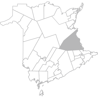
Geography
This community is part of Zone 1 - Moncton and South-East Area
Municipalities included in this community are:
- Acadieville
- Adamsville
- Aldouane
- Baie de Bouctouche
- Balla Philip
- Bass River
- Beersville
- Birch Ridge
- Bonar Law Historic Site
- Bouctouche
- Browns Yard
- Buctouche First Nation
- Cails Mills
- Caissie Cape
- Canisto
- Childs Creek
- Clairville
- Coal Branch
- Cocagne
- Dundas
- East Branch
- Elsipogtog First Nation
- Ford Bank
- Fords Mills
- Galloway
- Gladeside
- Grande-Digue
- Harcourt
- Haut-Saint-Antoine
- Huskisson
- Hébert
- Indian Island First Nation
- Jardineville
- Kent Junction
- Kouchibouguac
- Kouchibouguac National Park
- Laketon
- Main River
- McKees Mills
- Mcintosh Hill
- Mundleville
- Noinville
- Notre-Dame
- Pelerin
- Pine Ridge
- Pointe Dixon Point
- Pointe-Sapin
- Portage St-Louis
- Renauds Mills
- Rexton
- Richibouctou-Village
- Richibucto First Nation
- Saint-Antoine
- Saint-Antoine Sud
- Saint-Antoine-de-Kent
- Saint-Charles
- Saint-Edouard-de-Kent
- Saint-Grégoire
- Saint-Ignace
- Saint-Joseph-de-Kent
- Saint-Louis-de-Kent
- Saint-Maurice
- Saint-Paul
- Saint-Thomas-de-Kent
- Sainte-Anne-de-Kent
- Sainte-Marie-de-Kent
- Smith's Corner
- South Branch Kent Co
- St-Antoine Nord
- Targettville
- Upper Rexton
- West Branch
- Acadieville
- Aldouane
- Balla Philip
- Beersville
- Bonar Law Historic Site
- Adamsville
- Baie de Bouctouche
- Bass River
- Birch Ridge
- Bouctouche
- Browns Yard
- Cails Mills
- Canisto
- Clairville
- Cocagne
- East Branch
- Ford Bank
- Galloway
- Grande-Digue
- Haut-Saint-Antoine
- Huskisson
- Jardineville
- Kouchibouguac
- Laketon
- Mcintosh Hill
- Mundleville
- Notre-Dame
- Pine Ridge
- Pointe-Sapin
- Renauds Mills
- Richibouctou-Village
- Saint-Antoine
- Saint-Antoine-de-Kent
- Saint-Edouard-de-Kent
- Saint-Ignace
- Saint-Louis-de-Kent
- Saint-Paul
- Sainte-Anne-de-Kent
- Smith's Corner
- St-Antoine Nord
- Upper Rexton
- Buctouche First Nation
- Caissie Cape
- Childs Creek
- Coal Branch
- Dundas
- Elsipogtog First Nation
- Fords Mills
- Gladeside
- Harcourt
- Hébert
- Indian Island First Nation
- Kent Junction
- Kouchibouguac National Park
- Main River
- McKees Mills
- Noinville
- Pelerin
- Pointe Dixon Point
- Portage St-Louis
- Rexton
- Richibucto First Nation
- Saint-Antoine Sud
- Saint-Charles
- Saint-Grégoire
- Saint-Joseph-de-Kent
- Saint-Maurice
- Saint-Thomas-de-Kent
- Sainte-Marie-de-Kent
- South Branch Kent Co
- Targettville
- West Branch
Note:
The geographic boundaries of this community have been modified since 2020.
Users are advised to exercise caution if comparing data from these geographic areas to previous data cycles. For the affected geographic areas, comparisons between data cycles may not be precise.